 Filter: Categories of Wisconsin Historical Images
Filter: FORMAT_NUMBER_ORG of H GX902 1852 S
Filter: Categories of Wisconsin Historical Images
Filter: FORMAT_NUMBER_ORG of H GX902 1852 S
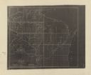
| Date: | 1852 |
|---|---|
| Description: | This map shows township grid with survey progress, military posts, areas of Indian habitation, cession areas, and treaty lines. Shows the entire state of W... |
If you didn't find the material you searched for, our Library Reference Staff can help.
Call our reference desk at 608-264-6535 or email us at: